Precise and Accurate Heading
The Furuno SC-130 is the latest satellite compasses built on FURUNO’s commercial-grade technology platform. These satellite compasses prove their value by increasing the accuracy of other devices, such as Radar, ARPA, Scanning Sonar, Current Indicator, Chart Plotter, ECDIS and Autopilots. They provide a highly accurate heading input to these other technologies by utilizing the very latest GNSS (Global Navigation Satellite System). This satellite system is comprised of GPS, Galileo and GLONASS to ensure the highest precision and a continuous coverage.
Bow and Stern Monitoring For Safe Berthing
The Satellite Compass provides a variety of data, including GPS Positioning, SOG (Speed Over Ground), COG (Course Over Ground), ROT (Rate of Turn) and 3-axis speed (bow, stern and longitudinal). All these data assist with critical maneuvers, such as berthing. The Compass is maintenance-free – a great asset for any vessel – and connects easily into the existing shipboard network via Ethernet connection.
Features
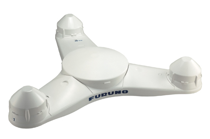
- Tri-sensor antenna that provides a high system accuracy for the heading of your vessel
- Utilizes GNSS such as GPS, Galileo and GLONASS for high precision
- Speed on 3-axis (Bow, stern and longitudinal) for safe navigating and berthing
- Type-approved as THD, GPS and ROTI*. Complying with following requirements (For Solas Vessels)
- Easily integrated into the existing shipboard network via Ethernet
- Rapid follow-up rate 40°/S
- Maintenance free and no recurring cost as there are no mechanical parts
- Super short starting time – 90 seconds
- Easy to retrofit by using existing antenna cabling
- Precision Pitch/Roll data in Analog and Digital formats for vessel stabilization, SONAR, etc.
- Ethernet interfaces for data communication with Integrated Navigation Systems or Central Alert Management Displays
- Perfect for installation in newbuild and for retrofit projects or an extension of Standard 22 gyro compass systems
- IMO approved for standard and high-speed crafts and as rate-of turn indicator
*requires the RD-50 as display unit
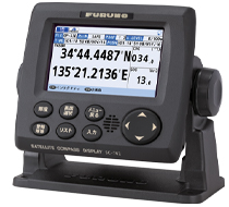
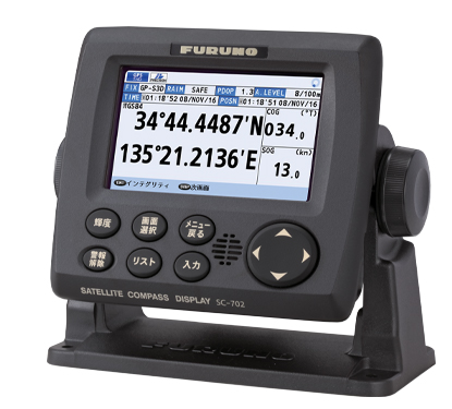
IMO Type Approved as THD, GPS and ROTI
The SC-130 provides highly accurate heading data of 0.25° for autopilot, Radar, ARPA, Scanning Sonar, Current Indicator, Chart Plotter, ECDIS and Autopilots. It is ideal for medium to large vessels navigating in crowded ports and making precise maneuvers, such as berthing and docking, and is IMO Type-approved as THD, GPS and ROTI, complying with the IEC/ISO requirements. It features a rapid follow-up rate 40°/s, twice the IMO high-speed craft requirement of 20°/s.
Ask Us for More Information?
Contact one of our specialists for more information or a quotation!